Country:China>Jiangsu>Nanjing
8th Floor, Building 3, Xinghe World Industrial Park, 56 Lingzhi Road
Company:Feiyan Aerial Remote Sensing Tech Co., Ltd
Mobile:
Tell:+86 15005176088
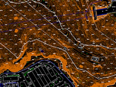
DLGs Topographic Data Processing Service Sensor: DMC II-230 Flight platform: Cessna 208B Height: 2300m Resolution: 0.2m Project area: 8,500km2 Duration: 4 days Output: DEM, orthophoto or video version Looking for reliable topographic data processing services provider? DLGs Topographic Data Processing Service Provider - Feiyan Technology Our topographic data processing service provider offers accurate and efficient data processing solutions for your project. We use the latest technology and software to ensure high-quality results that meet your specific requirements. Our team of experts has extensive experience in the field of topographic data processing and can handle projects of any size or complexity. We prioritize client satisfaction and offer timely delivery of projects at competitive prices. ★ Contact us today to learn more about our topographic data processing services from Feiyan Technology, and how we can help you achieve your project goals. Or feel free to by e-mail at frank*ntech.com.
Avoid fraud by meeting all sellers in-person to pay for items. BestB2B.COM does not offer any transaction or payment services.